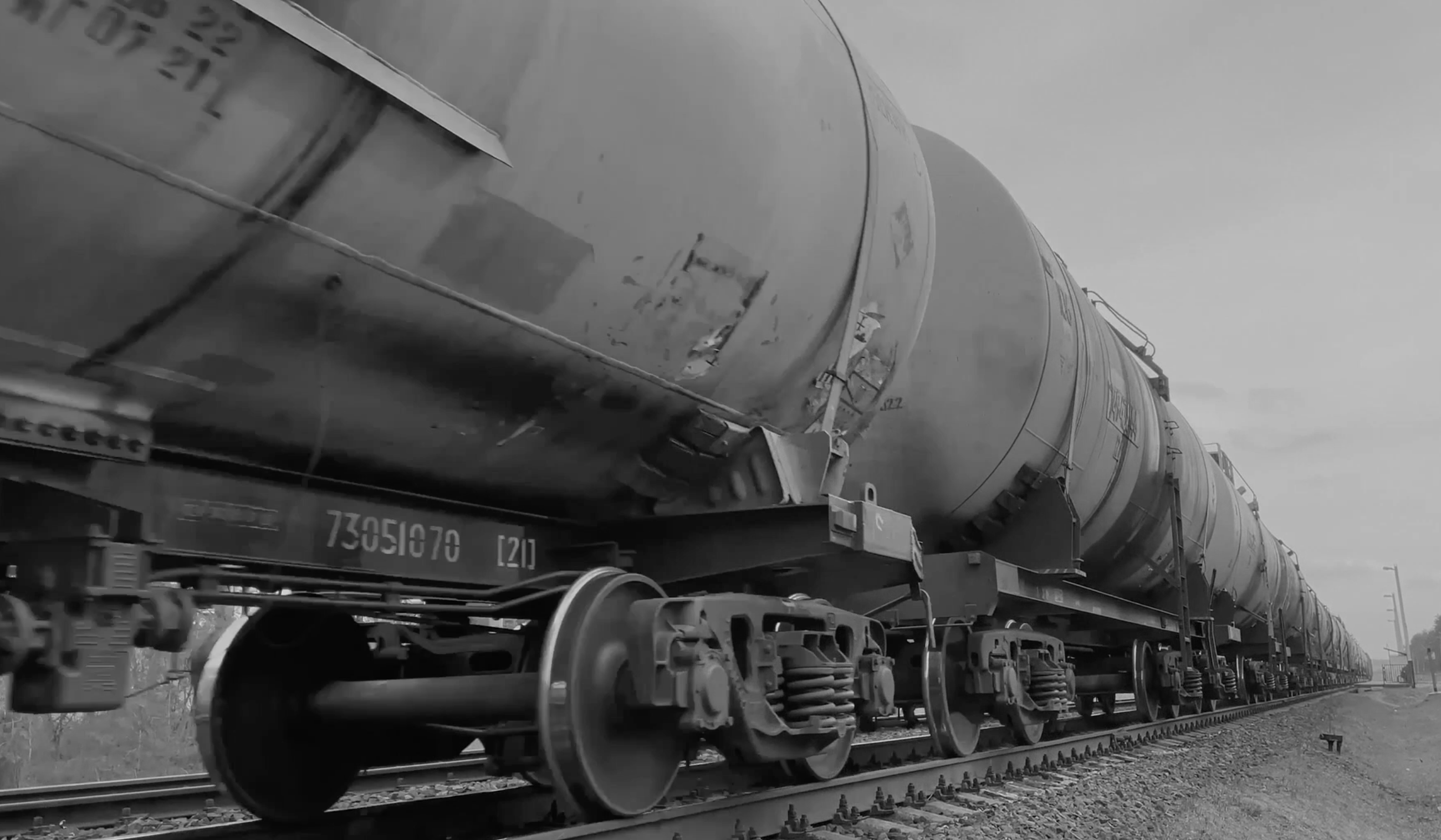
1: Oil Transportation by Train
Virtually all oil received in Washington prior to train transportation was received by ship or pipeline. The increased amount of oil
transported by trains introduces risk to the communities and environments surrounding these tracks.
- The transportation of crude oil by train in Washington began in 2012
(WSDOT. pg. 2).
- In 2018, 27.8% or (59.6 bbls) of all Washington oil was transported by train
(WSDOT. pg. 76).
- The oil comes from Bakken oil fields in North Dakota, Montana, and Canada (WSDOT. pg. 76).
- Washington Dept of Transportation says, “...rail shipment has provided a quicker, more flexible alternative" (WSDOT. pg. 76).
This map contains Washington train rail data and Washington oil refinery data.
The map also displays train routes that carry crude oil and natural gas products, along with Washington oil refinery locations.
Click the points to display refinery information.
Please refresh the page if map layers are not showing.
2: Population and Waterway risk
"Routes that carry oil by train pass through large cities, populated areas, and natural areas in Washington.
Large segments of the rail routes travel along the I-5 corridor,
and cross or run next to major waterways, including the Columbia River and Puget Sound" (WSDOT. pg. 2).
Oil transported by train introduces risk to the following areas:
- Populated residential areas and vulnerable communities.
- Waterways that host culturally significant species and habitat.
- Wetlands and other natural ecosystems.
Scroll north and south along the train line to see the rail's proximity to the Columbia River, the Puget Sound, and population
centers such as Seattle, Tacoma, Bellingham, Vancouver, etc.
3: Impact on Seattle Residential Areas
"While regulatory agencies and first responders have been prepared for the potential risks associated with shipping
oil by ship or pipeline, shipment of oil by rail presents new risks related to spills. Several explosive derailments
involving trains carrying Bakken oil have raised concerns about the volatility of the oil and the potential effect of
a derailment in Washington communities" (WSDOT. pg. 76).
"A one-mile or more evacuation zone can result when there are explosions and fires involving multiple tanker cars that
can produce extensive plumes of toxic fumes, smoke, particulate matter and heat at significant distances from burning
oil tankers" (Center for Biological Diversity).
- A half mile evacuation zone is recommended when a train derails, but it is extended to one mile when oil is spilled.
- Oil fires represent a risk to communities living within a mile from the track.
- In Seattle alone, 21,287 single and multi-family homes are within one mile radius of the track running through their
city.
- If an oil tanker were to derail in Seattle, tens of thousands of people could be injured and many millions of dollars in property damage could occur.
This map contains Seattle, Washington single and muli-family home data.
4: Spills into Waterways
Protecting waterways such as the Puget Sound becomes increasingly important when considering the significance of the
species that live within them. An oil spill could have irreversible damage on nearshore salmon habitat and resident
killer whale habitat.
- Other threats to the health of the Puget Sound include “pulp, paper mills, oil refineries, ports, boatyards, and storm-water runoff” (Olsen, 2022, p. 3),
that cause the degradation of freshwater habitats (Couture, 2022)
.
- In the spring, salmon make up the entire diet of north resident killer whales (Hanson, 2021). Oil refineries that
pollute salmon habitat have a direct impact on resident killer whale populations (Williams, 2011).
- Without sufficient salmon abundance in Washington, population recovery for these whales is impossible (Hanson, 2021).
- Killer whales are a cultural and historical icon to the Pacific Northwest, living together with indigenous people in
the Puget Sound for 5,000 years (EPA, 2023). Damaging the habitat of historically abundant food sources will
continue to endanger the resident killer whale.
- Washington's regulatory code RCW 88.16.190 states that “...a catastrophic spill would inflict potentially irreversible damage on the endangered southern resident killer whales” (Washington State Legislature)
.
This map includes Puget Sound Data..
5: Effects on Wetlands
Wetlands are a vital environmental asset to Washington state. "Wetlands are among the most productive ecosystem in the
world, comparable to rain forests and coral reefs. An immense variety of species of microbes, plants, insects, amphibians,
reptiles, birds, fish, and mammals can be part of a wetland system" (EPA).
This map displays all Washington wetlands within one mile from the track,
occupying ~120,000 square miles of at-risk wetland areas.
- Similarly to residential communities, wetlands could be damaged by toxic air pollution, smoke, and oil fires up to or more than one mile from the track. (Center for Biological Diversity)
- In Washington, ~10,000 wetlands are put at risk by train routes carrying oil.
- ~120,000 square miles of wetland areas are put at risk by train routes carrying oil.
Scroll along the train line to see the wetlands that are put at risk.
This map contains Wetlands Data.
6: Tribal Land Intersect
This map displays the tribal areas that are within one mile of BNSF oil railway. These railways cut through tribal lands in Washington,
subjecting these lands to the risk of waterway pollution, damage to protected fishing areas, risk of wetland pollution, and risk to residential areas.
On top of environmental and population risk, BNSF oil railways have a history of treating these populations and areas with a lack of
respect.
- In 2015, the Swinomish Indian Tribal Community were forced to file a suit against BNSF due to the breach of their 1991 agreement
which limited their traffic to 25 cars a day.
- "The railroad began delivering 100-car unit trains carrying Bakken crude oil to a nearby refinery in 2012, despite objections
from tribal leaders." (RailNews)
- "The case concluded against the backdrop of a March 16 derailment of two BNSF diesels and resulting in 3,100 gallons of fuel
spilling into waters in which the tribe has treaty-protected fishing rights" (RailNews)
.
Scroll and zoom in to see the BNSF rail lines that intersect Tribal Lands in Washington.
This map includes Tribal Lands Data.
7: Swinomish
This map shows the location of the BNSF oil spill that led to the conclusion of the Swinomish lawsuit. "The derailment in
Washington occurred on a berm along Padilla Bay, on the Swinomish tribal reservation near Anacortes. Most of 5,000 gallons
(nearly 19,000 liters) of spilled diesel fuel leaked on the land side of the berm rather than toward the water, according
to the state Ecology Department" (NPR).
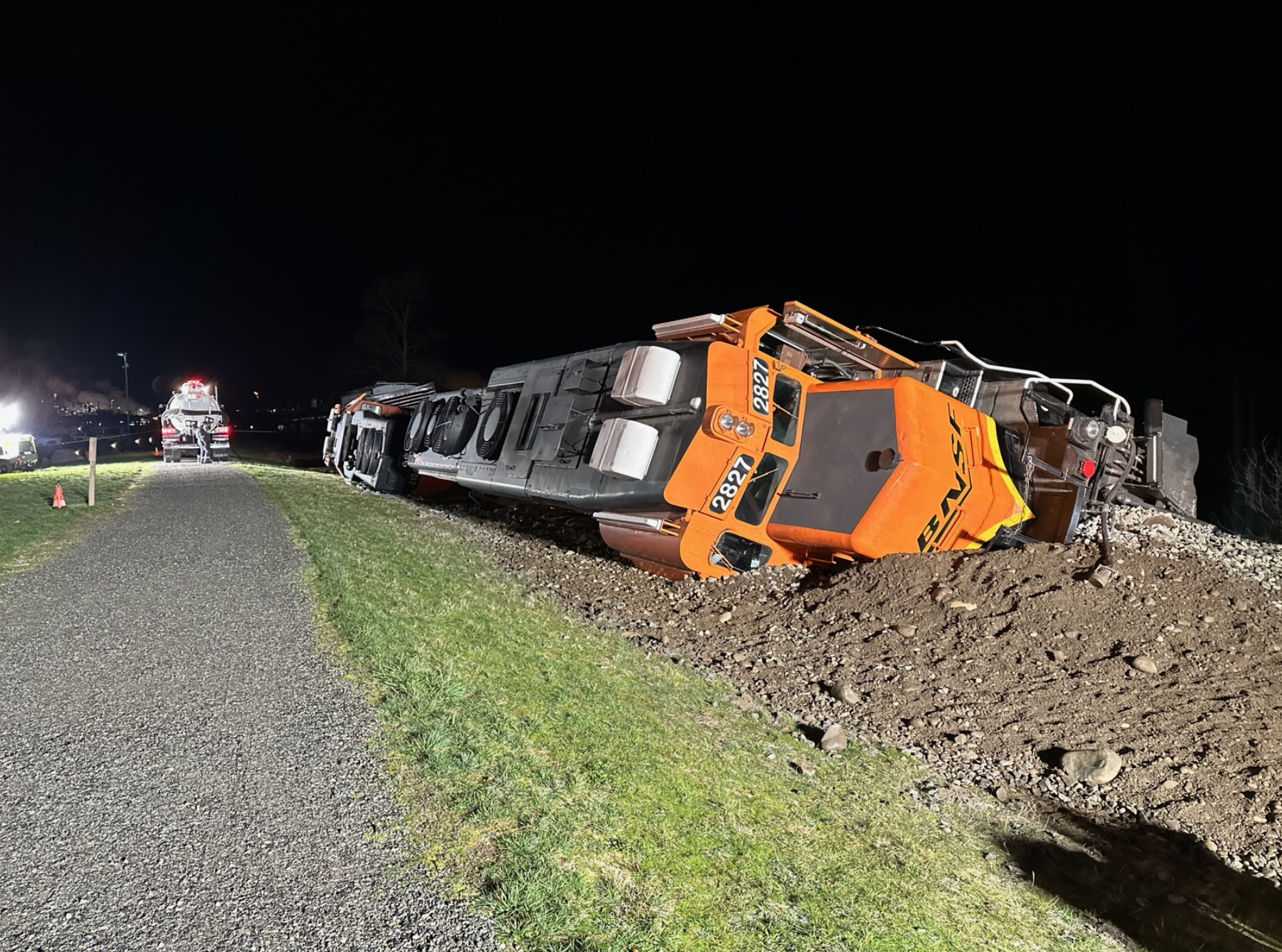
Photo Source:
8: Custer
This map shows the location of the BNSF train derailment that spilled oil in proximity to the Lummi tribal reservation. "At
approximately 11:40 am on December 22, 2020 a BNSF train derailed at mile post 111.7 near Custer, WA. Ten rail cars
derailed with several overturning, spilling Bakken crude oil. Three of those cars leaked oil and caught fire"
By Tuesday Jan 12th, "An estimated 28,962 gallons of oil were lost in the incident. Much of that amount burned up,
evaporated or was recovered afterward, leaving 5,400 to 8,000 gallons unrecovered.(NPR)
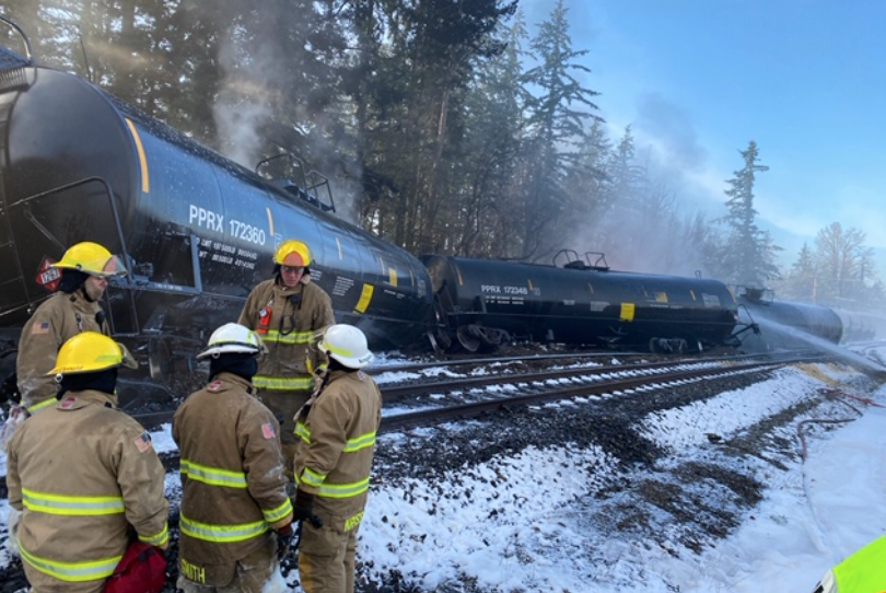
Photo Source: